2008 - Buenos Aires to Machu Picchu

October 2nd: 
Flight to Buenos Aires Well I made it to B.A (just over 11 hours of flying). Groggy from no sleep, I arrive at the aeropuerto and passed through customs around 6:30 in the morning. I had been told by Mariano (of Motocare) that a taxi to their shop would cost about 30 dollars. Well at that time of the morning and in comatose conditions I ended up paying over 100.00 to a taxi driver in suit and tie. Go figure. I guess is should go well from here. How can I get taken any worse that that? I leave tomorrow morning (Saturday the 4th) The bike looks good and I'm loaded up and ready. Buenos Aires, at least the part I'm staying in is rather different that I expected. Except for major streets, many intersections don't have street signs. The two taxis I've taken today both had problems finding the addresses given. We definitely should consider ourselves lucky to have basic things like stop signs or lights. Many intersections here have neither. Mariano Calderon has been wonderful to rent the bike from. I'm sure he has his fingers crossed that I get the moto back in good condition. He has even loaned me a cell phone. Motocare has a very good web site: http://www.motocare.com.ar/rental

Day One (Oct.4): 
B.A to Villa Maria Crossing Kansas? Long straight road with a brisk cross-wind. Lots of hawks of all things! Many hawks. I've never seen so many even when I've been training my homing pigeons at home I've never imagined these numbers. I estimate that I saw 40-50 today. About a third of all winged critters out there. Otherwise mostly cows and horses. Argentinians must love horses (I haven't seen any Gauchos however). Villa Maria is a rather large town. I needed help from the hotel staff to find my way out of the confusing downtown. Once again most intersection have no stop signs or street markers. Thank goodness the major ones do! 

Day Two (Oct. 5): 
Villa Maria to San Miguel de Tucuman Being the genius I am, I chose a route to Tucuman that by-passed another very large city and took me closer to the mountains. Well I saw the mountains off to the left as I again crossed Kansas. Absolutely straight and flat for about 250 miles then some rolling hills and more flat. Not particularly attractive part of Argentina. This was a day of the "goat". Yep! By my estimate I saw over a thousand goats grazing by the highway. From 10 to 100 feet from the two lane blacktop were goats. Some groups were small, about 20-30 head while some groups were 75-100 in a single group. Oh and I saw a few sheep but very few horses and cows. Route 9 took me straight to Tucuman. At about 4:30 I was tired and thought about getting lucky with finding a decent hotel somewhere in the coming miles. Sadly I think the "coming miles" were about 200! No town in that last half of the day was big enough to have a hotel. The towns reminded me of Central American villages with dirt roads and shacks. And dogs. When I finally arrived at about 7:00 it was getting dark and I drove about 3-4 miles through seriously impoverished (we call ghetto back home) area. I managed to ask two young guys on a moto if they would show me where there was a hotel and after abut two more miles of this huge city we arrived "downtown" Wow. The hotel is first class! I've never stayed in one this posh. I'm so tired I don't think I'll even "spell-check" Tomorrow will probably be a short day. 
Day Three (Oct. 6): 
San Miguel de Tucuman to Jujuy This day was as different as possible from yesterday. I leave Tucuman until around 10:00 after a visit to three banks. The first two wouldn't accept my ATM card that I got from AAA. I didn't have any problem with these cards in "06 through Central America but today. . . another element to the adventure. The ride to Jujuy was not straight and not flat. Mountains were just a few miles to my left for the majority of the trip. Although its early spring here, today was HOT. The first two days topped out about 65 degrees but today must have been 85. Jujuy like Tucuman was seeming endless streets without signs. I spent a half hour driving around looking for the "city center". And when I found it, it was awesome. Chaotic one-way streets without stop signs. Only on highways are there occasional stop lights. Not within the towns. You really don't want to ride a motorcycle in cities like this. Maybe I'll get out tomorrow in one piece. Note: almost didn't get out with the motorcycle in one piece. The hotel had visitor parking in a space which amounted to a basement. The ramp going down was short and steep. I worried about getting back out and sure enough just as I got to the top of the ramp the bike died and fell over. It was still on an incline and it took four of us to get it up and ready to go. It didn't appear that anything other than the mirror being twisted and a couple of small scratches that the bike was hurt. Of course my pride was really hurt.

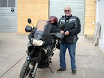
1. Man and his daughter wanted a photo with my bike. Two nearby boys came to join the fun. 

2. My Honda Transalp parked in front of a hotel. Most hotels, like this one, had secure parking. 

3 & 4. Street images from cities heading north.


Chile

Day 4 (Oct. 7)
Jujuy to San Pedro de Atacama, Chile

Jujuy was a short day and I planned another short day riding about 4 hours to Susques. Susques is the last gas stop before the big hills. Its also a bit over 11,000 feet. My plan was to stay the night and acclimate to the altitude before encountering Paso de Jama and its 15,853 feet (on the Chilean side). Well the one hotel in Susques was booked by a tourist bus load and I was looking at 180 miles of Andes to get to the next stop. I left Susques at about 2:45 with all the pent up worries about how I would deal with high altitudes. Knowing that you usually can't average many mph in the mountains I was looking at getting into Chile's first town (San Pedro) at between 7-7:30. Fortunately I made good time and arrive at the Chilean Aduana around 6:30. It's so good to have enough daylight to find suitable lodging. Well if you call $48 bucks for a tiny room with no TV or AC.

Other than a few trucks and fewer cars there was no traffic. Just height. At the Argentine officina de aduana (customs) I wasn't at all sure of my condition. The Aduana was at, I imagine, the highest of places. Getting off the bike I felt strange and walking inside the office was likewise. I asked to sit while they processed my papers. I think the "cold" may have affected me as much as the thin air. I clearly didn't dress warm enough. I needed 3-4 shirts under my heavy coat instead of two. Long Johns would have be good as well.

I have read that the Jama pass gradually increases from the Argentine side until reaching 15,853 ft and when it gets close to San Pedro de Atacama it just drops. Yes indeed. My guess is it drops from maybe 12-13,000 feet to 2,500 in about 15 miles. The incline was so great for that a distance big trucks were crawling along about 5 mph. The incline was an almost completely straight road for several miles. There were 3 trucks that couldn't even make it up the incline and one or two that had stopped completely going down.

The animal of the day was clearly the "Llama". Not as many llamas as goats the day before but quite a few. At least you could see them running across the barren land so I didn't have the same fear that deer give you, when they "pop out" of the woods, back home.

By the way for you bicycle enthusiasts I passed two bikes coming from the Chilean side crossing the Paso de Jama. One was a lone rider heavily packed and the other was a man and woman on a tandem. The couple looked to be in their 50's. Amazing!
Day 5 (Oct. 8)
San Pedro de Atacama (second day)

Had a great steak, got laundry done, worked on e-mails and web page and otherwise hung-out. Enjoyed more interaction with the Americans. One couple was from Montana and the other from South Carolina.

Unlike my experience in Mexico and Central America, breakfast (desayuno) is not a major meal. Most hotels have a light breakfast of fruit, croissants, and bread with thin sliced ham and cheese. Unfortunately the last couple of times they served "Nescafe" coffee instead of the good stuff. Pastries with fruity filling are popular in shops and really great ice cream is abundant.


Day 6 (Oct. 9)
San Pedro de Atacama to Pozo Almonte

Not a fun day so I kept it short (270 miles) The Atacama desert does appear as advertised. The driest on earth. I'm glad that I only rode about 200 miles. It was hot and dry and a bit boring after about 20. Straight as can be with about 150 miles with no towns, gas stations or Llamas. For more info on the Atacama desert.
The real fun began when I reached a gas station at Officina Victoria. Five dogs (I think three were German shepards attacked me as I slowed in the gravel next to the gas pump. I was of course worried about the loose gravel and keeping my balance. One shepard bit me twice! Crap! I've a nice bruise but no blood. Well you can imagine why I'm happy to make it a short day. Tomorrow I will reach the Peru border. Pozo Almonte is a small town right on the highway. Not much to say other than the hotel is nice and the people even nicer.


Day 7 (Oct. 10)
Pozo Almonte to Moquigua, Peru

A day of contrasts. The Atacama stretched on for miles then mountains then more desert then more mountains. The border crossing was hell. It took about 30 minutes at the Chilean Aduana only to find when I went down the road a bit the Peruvian's said I still needed one "stamp". This of course took another 20 minutes and then the Peru Aduana took about 30 minutes to complete their task.

Tacna was the first city in Peru and its a "Whopper". Imacculate with two rows of palms on a wide divider down the main street. This main street went on for about a mile. Then (because there was of course no signs showing the direction to Moquigua) I rode for another mile or so before wondering about the lack of signs and found that I was lost. Asking 3-4 people didn't help until a Taxi driver recognized my plight and had me follow him. Seriously you would think once in a town as huge as Tacna there would be signs to the next major cities. From the border heading toward Tacna there were multiple signs showing "Tacna and Moquigua".

Moquigua is also large (I don't think as large as Tacna). Located in the mountains there seems to be a 1-2 mile long main street with only three or four secondary street on either side. Once again my stupid limited Spanish made it hard to understand the directions people were giving me when I asked about "un hotel". Oh well tomorrow is another day. By the way, I'm sure most of you know how the days are hot and nights are cold in the desert, boy is that right.


1. Switchbacks leading to the high Andes. Eventually reaching nearly 15,000 feet.
2. Llama crossing. There were many llamas and alpacas in the Andes.
3 & 4. Images of San Pedro's tourist haven.

Peru north to Cusco

Day 8 (Oct. 11)
Moquigua to Juliaca

From Moquigua it was about 80 miles of desert leading to Ariquipa. Then back to the mountains. Big ones. Another pass around 15,000. Juliaca is a bit over 13,000 feet so I'm acclimating tonight. Big towns with incredibly crowded and
narrow street are bad enough for someone on a moto but when you don't know where you're going, it's REALLY tough. The streets of Juliaca are so crowded its virtually unbelievable. Three wheeled bike taxis and motorized three-wheelers as well. Sometimes 3-4 wide fighting for space with large vehicles and full sized taxis.

My extra gas can that I've been carrying for emergencies came in handy today. I didn't expect the 4-5 towns between Ariquipa and Juliaca to be without filling stations. So the mountains almost had a new resident as my tank was depleted with several miles to go. Unlike in Argentina and most of Chile gas stations in Peru are just gas. Nothing vended or offered for sale. In fact I didn't see a single "restaurante" sign anywhere except inside the big cities.


Day 9
(Oct. 12)
Juliaca to Cusco

A good short day of around 250 miles. For the first time on this trip I saw mountains with vegetation. Some green valleys and a couple of rivers. Still pretty barren but more green. Cusco, I'm told is around 300,000. Not much to comment on until you get to the central district and Plaza de Armas.

When I arrived I immediately was greeted by a man that showed me to a hotel and gave me information about his tour offerings to Machu Picchu. The hotel was three blocks from the Plaza de Armas. This area reminded me of Antiqua, Guatemala with tourists everywhere. However the age and beauty of the Inca buildings are fantastic. The famous (to moto travelers) "Norton Rats Bar" was on one corner of the plaza.

Tomorrow morning I'm being bussed to Agua Caliente (6 hour drive). This route will take us through the "sacred valley of the Incas".


Day 10 (Oct. 13)

Cusco to Aguas Caliente


The Sacred Valley is the portion of the Urubamba river valley from Pisac to Ollantaytambo. The Sacred Valley was home to several cultures prior to the rise of the Inca Empire.

The valley is guarded at either end by Inca citadels hanging high above the valley floor. The stronghold at Ollantaytambo was the only Inca fortress to withstand a sustained Spanish attack.
The Sacred Valley was absolutely beautiful. Pisac is a location of an ancient Inca village and we stopped for about two hours for a trek into the mountain. I recognized my limitations and just took pictures without the trek. I think saving my knees for tomorrow at Machu Picchu is a good idea. We arrived at Olantambo (another very old Inca city and two of us from the bus got on the train for Aquas Caliente which is the only way to get there. This is a great way to celebrate my 65th birthday! Machu Picchu would perhaps have been better for the occasion but the sacred valley was pretty special.
The train usually takes about 90 minutes but because they knew I was on an adventure the train people obliged. About 30 minutes into trip the train stopped. Just stopped dead. It was dark except for a full moon and no one knew for almost two hours what was wrong. There were two sets of tracks along a mountain wall and next to a river. We were passed by two complete trains and one really short train (like an engine and one car). Well it turned out that our engine was not strong enough to continue but was, thank goodness, strong enough to be unhooked and sent back to where it came from! A new engine was sent out to us and somehow they managed to hook us up and we finally arrived in Aguas Caliente two hour late (10:30).

I was met by tour representatives and taken to the hotel. The hotel was good and I had all I need for the big mountain except enough sleep. Some birthday right?


(above) Plaza de Armas. The central square in Cusco.(below)Young boy in Cusco that acted as a tour guide in addition to selling small woven finger puppets.


Look again at the above photo and you will see a small house. Typically
the tiny dwellings in many Latin countries have no windows and I suspect no toilets or running water.


Machu Picchu

Click on pictures to enlarge

Day 11 (Oct. 14)
Machu Picchu

Bright sunny day starting at 7:00. Warm and M.P was as advertised, fantastic. There were hundred of visitors arriving at about the same time and I somehow missed my tour guide so I guess that could have been better. The Incas were pretty good with stone and Machu Picchu is quite an example. My knees held out for almost three hours of walking and climbing.

I fully understand why this site is considered one of the seven wonders of the world. It’s location perched on a mountain top and surrounded by peaks makes for an impressive place. For more info on Machu Picchu.

Day 12 (Oct. 15)
Aquas Caliente to Cusco

Train ride went well to Olantambo but there was no bus there as planned. A taxi was arranged and it only took 90 minutes to return to Cusco. I'm getting laundry done and catching up on this site.


(above) Images taken at Machu Picchu.

(below) Images taken in the sacred valley.


Lake Titicaca/return to Chile

Day 13 (Oct. 16)
Cusco to Puno (Lake Titicaca)

Sadly, I had to endure the grotesk city of Juliaca in order to get a short distance south to Puno. Just getting thru the horridly confusing and congested streets was exhausting. The Drivers were as bad as any I had found on the trip so far. Finally at Puno I've checked in at an inexpensive hotel for two days in order to take a tour to the "floating islands of the Uros". For more info on Titicaca

I'm still amazed at the difference between Peru and the other two countries I've crossed. Filling stations that only offer gas (no “super” only 84 octane) and many small towns that don't appear to have restaurants or stores. I can only imagine that they may have them but to the passer-by they are invisible. Unlike the large cities which capitalize on tourist, small towns apparently have a life of their own.

click on photos to enlarge


Day 14 (Oct. 17)
Lake Titicaca

The Presidente hotel (fancy name for 13.00 per night) offers tours and this morning I'm going to the floating islands. Although most people probably never heard of Lake Titicaca, It's history is quite interesting. The sheer size of it without rivers contributing and being 12,500 feet elevation is worthy of awe. For those of you that have been to Colorado's "trail ridge road", The altitudes are similar.

Some of the 44 floating islands are primarily tourist attractions. Islands not pictured and could be seen from a distance had tin roofs and some had solar panels. Fishing, which is a primary meaning of subsistence, is now aided by some use of motor boats.
The tour was not the best but was educational and actually walking on the reeds that compose the islands body (approx. 2 meters thick) was unlike anything else. For those unfamiliar with Titicaca, it is large enough that decades ago Peru commissioned full size freighters to be carted piece by piece overland to be assembled for commerce. During the tour boat ride out to the islands our boat began to have trouble and for a short time quit running. I had the thought that how could I be on a train that quit on the way to Aquas Caliente and then be on a boat that quits in the middle of Lake Titicaca. Hmmmmm.

Day 15 (Oct. 18)
Puno to Moquegua

I took a different route returning to Chile and rode for about 70 miles trailing Titicaca's shore. Quite magnificent. The next 180 miles froze my butt in the high Andes as I turned west toward Moquegua. I'd seen many, many alpacca and llama in recent days but today was a feast. Apparently this particular part of the Andes really support the critters and there were hundreds.

This day was very intense as I had filled up with gas early that morning stupidly believing that one of the towns showing on my map would surely have gas. Of course there was no gas in those towns and with 40/50 kilometers to go to reach the city of Moquegua, my gauge was on empty. I had passed only a few vehicles so when I saw a small SUV pulled over by the side of the road, I pulled up to it. I asked if the man had gas and he said no and pointed in the direction I was going. I was now seriously worried about at the prospect of being stuck in the Andes out of gas. I continued for a kilometer or two and saw what might be called a village with only three or four buildings (huts). There were three men standing near the road talking and as I neared them I passed a woman sitting by the road and close to one of the small houses. I asked the men if there was gas nearby and they pointed at the woman. Huh? I turned around and rode back about twenty yards to the lady. Yes, she had gas! She went into a very small shed beside the small house and returned with a bucket of gasoline. Wow, was I lucky!

After arriving in Moquegua I found the same hotel I had stayed at before. I heard festivities and went to see. It was the "mother of all kid's parades". Evidently Moquegua hosts a parade featuring elementary school kids in ethnic costumes from all over Peru. One group was from Lima a few hundred miles to the north. I don't know how many groups there were, but I'm guessing 20 cities with different grades participating. Unlike many towns that have dogs barking all night, it was firecrackers or gun shots in the early morning hours in Moquegua. And strange that both times staying here it was the same loud bangs to wake you up.

(below) 1. Puno city center. Hectic traffic and lots of tourists.
2&3. Views of Uros floating islands


Chile - return trip

Day 16 (Oct. 19)
Moquegua to Pozo Almonte

Very rough day with heavy cross wind. Wore me out. About 300 miles of mountains and Alto Plano. The alto plano is like working your way up a tall mountain only to discover that is flatten out like a table top for another 50 miles. Then you get to wind your way down the mountain and repeat the scenario.

Pozo Almonte is a very small town (my kind). The hotel is very good and the food is great. I told the hotel manager, who speaks English, that I was considering going to Iquiqui which is about an hour from Pozo Almonte. Besides being a large ocean side city he said its best attractions were the beaches and para-sailing. I decided not to check out Iquiqui. I think I'll go from small town to small town for now (if possible).

Day 17 & 18 (Oct. 20)
Pozo Almonte to San Pedro de Atacama

This time I got into San Pedro in time to get a better hotel. Well there's no TV and so far the internet feature, that's provided it the main building, doesn't work. It's a cool place with lots of restaurants and shops, dusty unpaved streets and many tour companies. I hadn't noticed the first time here that everything from tours to the Salar de Luna, to horseback treks and bicycles outings are offered. Even "sand boarding" is popular in areas nearby.

One thing I did notice the first time was the dogs. For a small town there are many dogs. They lay flat out on streets and in shop doorways. And after dark they bark. The cool air must provoke them to run around and boss each other.

Day 19 (Oct. 22)
San Pedro de Atacama to Pumamarca

Crossing the Paso de Jama this time was a piece of cake. The highest part was warm and sunny. The Aduana (customs) was simple and quick. I made good time even though I stopped to take pictures. More llamas and not much traffic. The Andes seem to me to mostly be big and long. The few big trucks are slow going but easy to pass with a bike.

This photo
obtained on-line.
I didn't arrive
with enough
light to get the
beautiful colors.

(click to enlarge)

Pumamarca is known for its "mountain of seven colors". The switchbacks down from the high pass led to this beautiful part of the otherwise baren mountains. It’s located a few miles north of Jujuy and from the looks of the modern hotel architecture where I'm staying its probably tourist oriented. Arriving late in the day I chose the first hotel I came to. It was very nice with the largest cost I've paid, about $80 u.s. I’m leaving early to try to get to Salta as early as possible to meet up with Julio Rueda.


Two views of San Pedro de Atacama and breakfast with fellow Americans. It was rare to speak English on this trip.

Argentina return trip

Day 20 (Oct. 23)
Purmamarca to Salta, Argentina

The idea today was to get started early and contact Julio Rueda, an English speaking fellow in Salta. Julio is a good friend of people back in my home town of Columbia, Missouri. I wanted to get with Julio and find a recommended hotel before noon. Julio needed to be at work by that time. (Julio's family is pictured at left) Then came the headaches. First the fancy hotel in Purmamarca lost it's internet connection when I needed to check e-mail to get the hotel name and location in Salta. Lost 45 minutes.

Next I choose Ruta 9 which covered the last 50 miles into Salta and would avoid the super highway which would be about 85 miles or so. Well ruta 9 was the strangest highway I've ever seen. Great pavement, yes. About 1 1/2 lanes wide with no stripe. 10,000 hairpin curves with horses and cows on the roadway. Lost another 45-60 minutes.

Finally Salta. Home town to our Columbia friend Alicia Simon, Salta has the primary implements a thriving big city should have. Stop lights. With over a million people, Salta needs stop lights. I'm amazed that on this trip I've encountered so many towns without stop lights and some without any signage.

Julio led me to the hostel and after finding safe parking for the moto he introduced me to Alicia's sister Alejandra. Alejandra, who lives around the corner from my hostel, in advance of my arrival contacted her friend with the Salta newspaper about doing an article on me. Ah fame!

The area that my hostel is in has a comfortable feel with a nice mix of big and small buildings. For more info on Salta.

Ruta 9 was only a bit wider than
a single lane. Fortunately I shared
that space with horses and cows
and very few vehicles. If I hadn't
been in a hurry I might have
enjoyed the ride


Days- 21 & 22 (Oct. 24 & 25)
Salta

For a big city, Salta genuninely feels inviting. Alejandra took me for a very long walk last evening (although I was walked out from earlier in the day). She was so enthusiastic to show me the 1400's vintage church and other notable buildings. The main plaza was splendid with lots of people and wonderfully safe atmosphere.

The next day, Julio took me to a number of Salta's noteworthy sites. He also arranged to take me for an interview with Salta's newspaper for an article on my trip. My last day in Salta had a special treat when I met Julio's family and they took me to a special museum for the "three ninos" (the remains of three children found at the top of a high volcano). For anyone traveling to Argentina I would highly recommend visiting Salta.

Day- 23 (Oct. 27)
Salta to Termas de Rio Hondo

An easy 250 mile ride on a very hot day. I got a bit lost when going thru the huge city of San Miguel de Tucumen. Later I also had some problems navigating thru Santiago del Estero. Getting lost, I guess, is a part of an adventure.

Rio Honda is a spa-city that is situated on the banks of Río Dulce. A lot of visitors are attracted to this popular Argentine town. I rode around for probably 30 minutes before finding a hotel that was open. Most businesses here are closed for 2-3 hours in the early afternoon.

Many hotels and restaurants and lots of visitor/tourists. I really hate waiting until 8 or 9 to eat which is what they do here. With a lot of walking around I managed to find a restaurant that opened at 7:30! I looked over a dinner menu and chose Portuguese chicken. Lots of onion, tomato and boiled potatoes with the chicken. It was wonderful!

Day- 24 (Oct. 28)
Termas de Rio Hondo to La Para

La Para is a really clean little farming town complete with town square. The landscape reminds me of northern Missouri. Flat with fields of crops as far as you can see. It was long day and fairly hot but not so bad as yesterday. The quiet town square was similar to that of Bowling Green, Missouri that I remember from a few years ago. Very comfortable. I almost expect Opie Taylor and Barney Fief to walk down the sidewalk.

Day- 25 (Oct. 29)
La Para to Esperanza

Julio Rueda had suggested a good city to visit would be Esperanza and he was right. Very much like La Para only much bigger (I'm guessing maybe 30-35 thousand). It was amazing to see all ages on bikes and motorscooters. Sometimes three on a moto. Just cruising the town square. The town square (plaza) was the biggest I've ever seen. Equal to four city blocks. Huge trees and great walk ways with several sculptures and fully lit at night. Esperanza is in the middle of a great agricultural area. I could have spent more time there but it was so much like Missouri that I'm longing to get home.

Day- 26 (Oct. 30)
Esperanza to Pergamino

Pergamino is the last stop before Buenos Aires. This town is probably a bit larger than Columbia, Missouri (80-90,000) It was good getting here and settled in as this morning it rained rather hard before I left Esperanza. Lucky me as the dark clouds never actually opened up on me as I rode to Pergamino, and the sun finally came out.

I got lost twice in Santa Fe (a huge river city) and had to stop four people before I finally found the route toward Pergamino. I must have put on an extra 40 miles just finding the right highway out of this huge city.

The following images of Salta don't really give the full picture of the wonderful city.


Buenos Aires and summary

Day- 27 (Oct. 31)
Pergamino to Buenos Aires

A short ride into the big city. Got to Motocare around noon and after turning over the bike and repacking bags I was ready for B.A. Mariano (at the bike rental) had made a reservation for me at the hotel I stayed at the first night in Buenos Aires. I had decided to call the airlines to get a flight out on Sunday instead of Tuesday as orginally arranged. I didn’t need the two days of “padding” on my journey so why not go home and be ready for the November 4th elections.

After making the revised flight, I discovered that I was missing my Passport! OMG! Panic! I knew I had it at the Pergamino hotel and after looking everywhere in my room and the front desk and calling Mariano at Motocare. Nothing! More Panic. I found the address for the American Embassy and jumped in a taxi. The embassy was about two city blocks in size and formidable to get into. Fortunately I had a copy of the lost passport and was shown the way to a waiting area for passports and visas.

My blood pressure lowered when I was told that they could create a temporary passport. After only two and a half hours I had the new passport and was on my way back to the hotel.

I spent Saturday and Sunday walking around the area of the hotel and found it to be similar to Salta. Really nice architecture and interesting stores. Very comfortable. The hotel was located about 4-5 miles from the center of the city of Buenos Aires. My flight was to leave at 11:30 Sunday night so I killed time until about 8:00. I needed every bit of the nearly 3 1/2 hours I allowed! Every point that required to see a passport (3) apparently hadn’t seen a temporary one and a supervisor had to be consulted. I was the last person to board.
Well I’m home and rested now. Wondering if I’m too old for another adventure.


Summary of South America Adventure.
Miles total 5100 miles.

While this trip wasn’t anything like Che’s, it was an adventure. I think the ride itself was much less intense than the Central America one. However I realize that riding “solo” and knowing there is no one to turn to added an intensity that I didn’t have in ‘06.

I realize that world travelers surely resign themselves to not being able to converse with many people as they cross the globe with many languages encountered. However, even though
I made an effort to learn more Spanish, it wasn’t enough to converse with the people I met. I've now visited eight Latin countries with one common language. I regret not making a greater effort with Espanol.

While there were many differences between the ‘06 and ‘08 journeys, the poverty of Latin America was nearly overwhelming in both trips. The memories of the conditions and poverty are with me. I’m reminded by images of waste here in the U.S.

I think a significant benefit the 9346 miles of adventure has had for me was refreshing my sense of being “alive”. Retirement and health issues have weighed heavily on me and the planning and execution of these journeys have been good for my mental health.


Below are images of Buenos Aires close to my hotel.


About Me

My photo
Professional: Graphic design for Steven mfg., Art Director -MFA inc. and Missouri State Parks. Teaching: Stephens College, Columbia College, Virginia Commonwealth U. and Rolla Technical Institute.

Translate this site